Tag Archives: moose

Tuesday 23rd September 2014 – I SPENT LAST NIGHT …

esker lodge bay labrador coastal drive canada september 2014… sleeping in an esker.

I mean, I don’t mean sleeping IN an esker like that arctic explorer and fellow former Nantwich-dweller Jack Hornby and his companion James Critchell Bullock back 90-odd years ago.

They actually burrowed in like rabbits and built themselves a cave. I actually spent the night sleeping in an old quarry that has been formed where a load of sand had been removed from an esker.

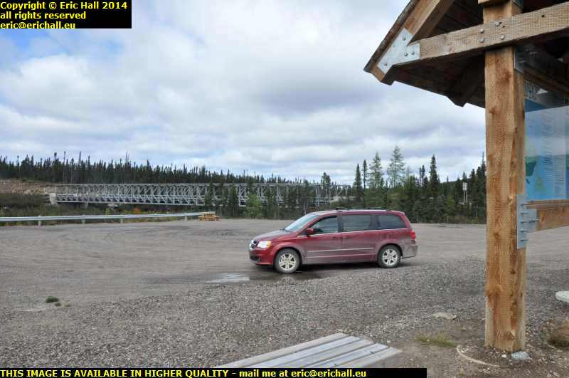
And an esker? It’s like a sandbank but has been deposited by a glacier rather than a river or a sea and the whole of northern Labrador is covered in them. This one is about 10 miles north of Lodge Bay.

And I was up even as dawn was breaking, and on my way. It was quite cold and damp and so I needed to warm up the Dodge before I could do much. A good drive for half an hour would sort that out

A sign of the times is how the raffic is on the roads around here. Back in 2010 you could drive for hours and not see another vehicle. Here on Iceberg Alley at the moment, at just 07:20 it’s like the M6. There’s a car coming towards me and there’s a car coming behind me too

st lewis iceberg alley labrador coastal drive canada september 2014At the end of Iceberg Alley is a small town called St Lewis and as I have said before
it’s one of the most beautiful places on earth, and this is where I’ve come for breakfast.

But they were quite right about the storm worsening today. I’ve tried to open the door to go out and take a photo but I physically can’t open the door against the wind. I had to turn the Dodge around. And the coffee that I made went down well too. I needed that.

sign next fuel 408 kilometres port hope simpson labrador coastal drive canada september 2014Fuel is also 152.9 cents per litre at Port Hope Simpson so I fuel up again. Not that I desperately need it but as I have said before, you should never pass up a reasonable opportunity to fill up your tank when you are out here

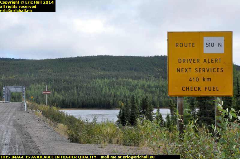
The reason is that it this sign that you are up against in areas like this. And if I’m going to look at Paradise River, something that I overlooked to do in 2010, then I’ll need an extra 100 kms of fuel at least for all of that

paradise river metis trail labrador coastal drive canada september 2014So this is Paradise River. It’s another place that could qualify for one of the most beautiful places on earth.

I can see how it got its name but as for the village itself, there’s no focal point or hint of any urban node – It’s a linear village and just stretches along the road on the shore of the river with a house here, a house there.

It was once a very much larger village but 1918 flu epidemic swept away a good proportion of the inhabitants and others have slowly drifted away. That’s quite evident by empty lots and abandoned property and state of one or two of the houses. Then again, people living in Paradise River would have an 80km round trip to the shops and to get fuel. How isolated is that for a village?

rest area labrador coastal drive canada september 2014There’s an area right by the junction where the road to Cartwright leaves the Labrador Coastal Drive that I’ve had my eye on ever since 2010. It would make a perfect motel, shop, cafe and fuel station.

However, it’s been usurped by the Newfoundland and Labrador Tourist Board as the principal tourist rest area for the trail. It weems that people have indeed been reading my notes but lack the capital to invest in the plot.

Now I’m heading right into the mountains. And the weather is fluctuating like no-one’s business. We’re having bright sunlight, then clouds, then torrential rain, and then back in the sunlight and it’s changing faster than it ever does in the Auvergne.

motorcyclists labrador coastal drive canada september 2014And if you want to kno the meaning of “intrepid”, have a look at this photo. These are two motorcyclists and they’ve come all the way round from Goose Bay, and probably from further round too.

A motorcycle doesn’t have the range to do this leg of the trail and these motorcyclists are stopping to fuel up their bikes out of cans. This is certainly adventurous.

rough road labrador coastal drive canada september 2014This is sample shot of the road where I stopped on one occasion and look how much this road has deteriorated compared to how it was in 2010. And this is far from being the worst part of it either.

It was never ever like this 4 years ago and I’ve no idea what might be in their heads letting the road deteriorate like this in just 4 years. It doesn’t say much for the long-term future of the road if it’s ended up like this.

lunch stop labrador coastal drive canada september 2014
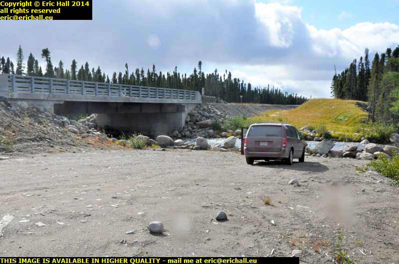
This is my lunch stop for this afternoon and isn’t it beautiful? The river doesn’t seem to be carrying a nameplate so I don’t know what it is, but the bridge is dated 2008 if that’s of any use. I could quite happily settle down here in this spot.

And just look at the poor Dodge. It’s looking as if it could do with a really good wash but it isn’t going to have one for a while yet.

labrador coastal drive canada september 2014This is the Valard Construction camp and there are enough mobile homes here to house a thousand people.

It seems that the Muskrat Falls at Goose Bay are to have a hydro-electric dam. The power is going to come this way on pylons and there will be side roads built to service the pylons. The power is togo all the way through to Forteau and then under the sea to Newfoundland and then under the sea again to Cape Breton and then Maine.

Its primary purpose is to provide electricity to the Province, earn revenue by exporting the surplus to Nova Scotia and the USA, and freeing themselves from Quebec Hydro’s oppressive grip.

And there’s talk of asphalting the whole length of this highway – in fact an asphalt plant has already been built.

labrador coastal drive canada september 2014
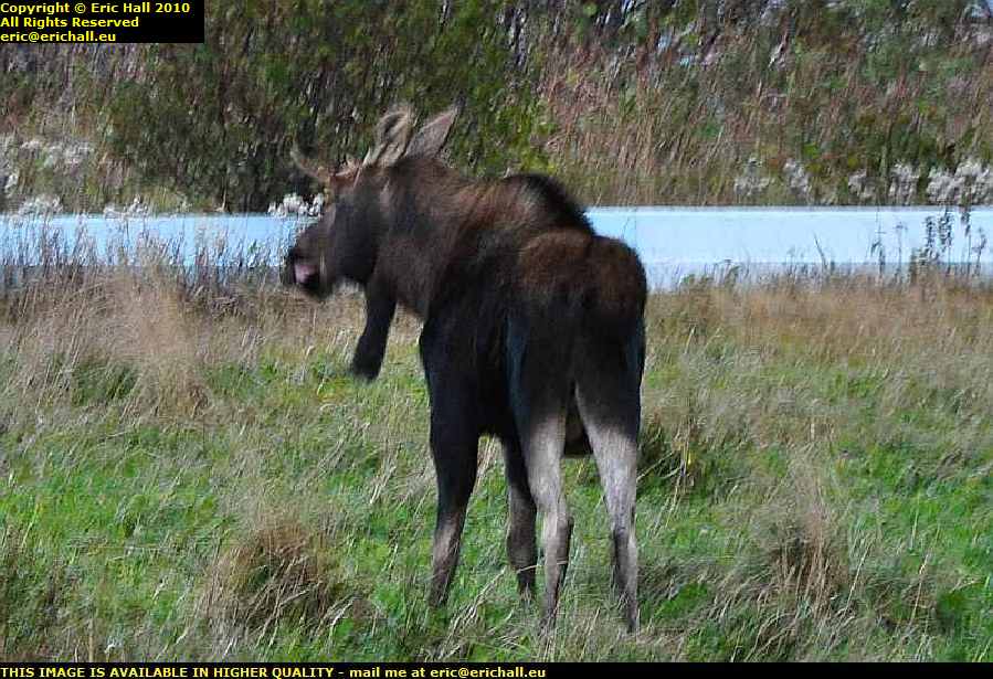
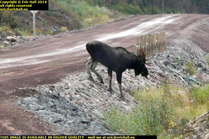
Standing in the middle of the road, acting as if he owned it, which he probably did, is our old friend Mr Moose.

He stood there as if challenging me to a contest but he was no match for Strawberry Moose and so he slowly lumbered out of the way to leave me with a clear path to drive all of the way down to Goose Bay. That was very good of him

north west river labrador coastal drive canada september 2014
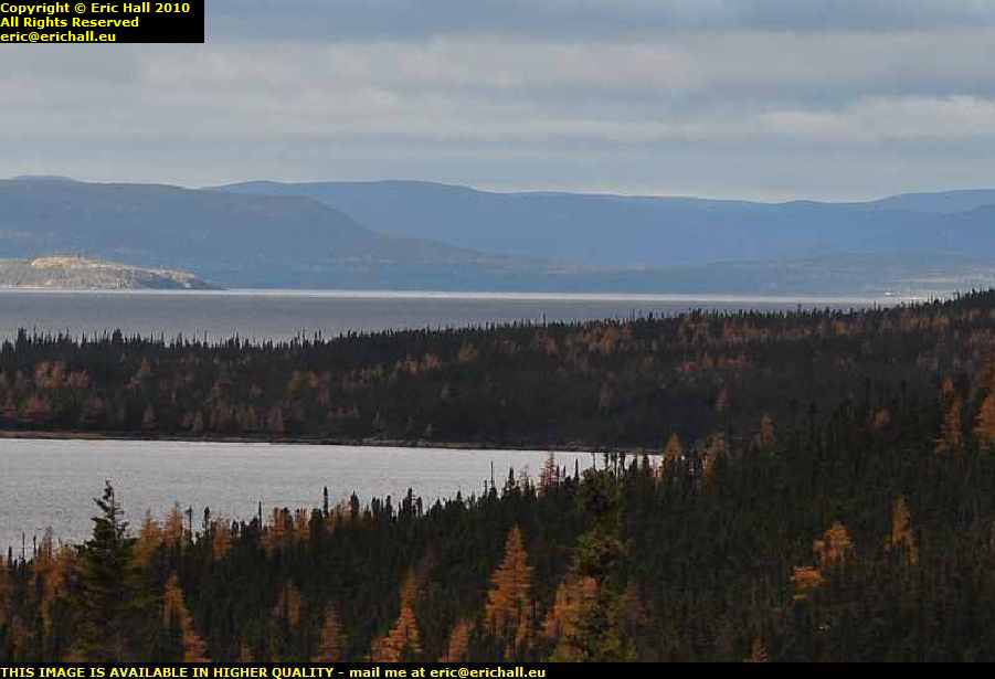
I didn’t stop in Goose Bay but went right through to North West River, the farthest northern point of the Province that it is feasible to reach by road.

This is a beautiful place to visit, especially in the setting sun. And it really did look this good too.

So now that I’ve accomplished this task, another one that I didn’t do in 2010, I retraced my steps to the docks at Goose Bay and I’ll settle down here for the night. This will do me

Saturday 16th October 2010 – WE MADE IT TO L’ANSE AUX MEADOWS TODAY

l'anse aux meadows viking settlement norse newfoundland canadaThe view is spectacular and you can understand why the Norse chose this particular site.

There are two crescent-moon shaped bays, both well-sheltered, next to each other surrounded by cliffs to the prevailing northern side, and a low bank behind to stop the easterly winds. The boats could be brought right up to the village when weather conditions were right but a sandbank has intervened these days.

l'anse aux meadows viking settlement norse newfoundland canadaUnfortunately, the place was all closed up and locked, but having driven all of this way to get here, I was not going to be thwarted.

A visitor centre with a low roof miles from anywhere where there isn’t anyone about is not going to be a barrier to anyone who is sufficiently determined, and 10 minutes later we were in the park.

ruins viking norse remains l'anse aux meadows newfoundland canadaIt’s a little confusing at first – they have built some replicas of the Viking buildings, but these are some way from the remains of the original Viking ruins.

The remains of the original buildings are surprisingly open. They are not fenced off at all to anyone so you can wander around them.

bog iron l'anse aux meadows viking settlement norse newfoundland canadaThere are all kinds of traces of bog iron too just floating on the surface of the bog. The Norse travellers would have found this very useful to repair their ships.

But after that I had to clear off smartish-like because the heavens opened and I was soaked to the skin just walking back to the car. And I don’t have long here and I have a lot to do.

You may not think it but Newfoundland is huge, much bigger than it looks on a map and I have to travel from here, at the extreme north-east, down to the Marconi station at the extreme south-west, and its over 1300 kms, would you believe.

deer lake motel newfoundland canadaAnd so in a kind of minimalist mode I’ve made it this evening to Deer Lake where I can pick up the Trans-Canada Highway eastward.

The motel isn’t as cheap (by a long way) as I’d been hoping, but around here there are not so many choices. There was a cheap bed-and-breakfast but no-one answered when I knocked on the door. It made me wish that I had bought a mobile phone as well as a Sat-Nav.

beautiful scenery north west newfoundland canadaThe drive along the Viking Trail down from l’Anse aux Meadows to here was almost 500 kms, you know and we went through some wonderful scenery, because Northern Newfoundland really is beautiful.

There are some really nice mountains and massifs and had the weather been better and had I had more time, I could have taken hundreds of photos along here but I was in a rush.

moose newfoundland canadaWe also saw some of Strawberry Moose‘s cousins. One was quite a good clear shot which came out blurred due to the darkness that was surrounding me.

As for the second – there were about 3 vehicles in a line – I was the middle one – and in the darkness and we were travelling at speed, suddenly the front car slammed on his brakes and screeched to a stop, and we saw four long legs in the headlight beam disappear into the forest. He had just had a close encounter with a moose. It was noticeable that for the remaining 30 kms to Deer Lake his speed dropped from over 100 kph down to about 70 kph.

Tomorrow I’m back on the highway and I want to do all of it to Saint Johns in one go. If I can find somewhere cheap to stay I’ll do 2 nights there, visit Cape Race and the Transatlantic Air Museum, and then head back to the south-western corner (Newfoundland is like a big triangle) to my ferry Thursday night.

Thursday 14th October 2010 – WELL, STRAWBERRY MOOSE HAD A GOOD DAY TODAY.

strawberry moose family labrador coastal drive canadaOn the road between Port Hope Simpson and Mary’s Harbour we encountered some more of his cousins. This time it was mother and daughter.

And a short while later we encountered another juvenile. So he’s having fun anyway, meeting up with all of his family and he’s ever so excited about it all. Good old Strawberry Moose

wunderstrand norse viking visit site cartwright labrador canadaAs for me, I’ve done nothing like as much as I hoped. But then again, I’ve been distracted. For a start I couldn’t get out to see the Wunderstrand.

Although it’s just across the bay from Cartwright, it’s actually a 10-mile walk followed by a 10-minute kayak journey (you need to carry your kayak the 10 miles, by the way), or else it’s half an hour across the bay in a kayak (in a howling wind across freezing cold water) and of course regular readers of these columns know that you couldn’t get warm again. You know that it’s against the law to light a fire in a canoe – you cannot have your kayak and heat it.

wunderstrand norse viking visit site cartwright labrador canadaThere is however a certain spot to which you can drive and with a long telephoto lens and a little judicious crop and sharpen, you can make out the beach right away in the distance and see just how beautiful it all is.

Of course a photo isn’t the same as actually walking in the footsteps of Eirik the Red at the climax of his magnificent epic voyage to Vinland, but I suppose that it’s the best that I can do

pinsent's arm labrador canadaAnyway, back on the Labrador Coastal Drive (as this bit of the Trans-Labrador Highway is called) the next stop was the most delightfully-named Pinsent’s Arm, a small fishing village on the coast in a sheltered bay off the Atlantic. I always thought that the name was quite romantic.

I had to ask directions when I got to Charlottetown. I hailed a passing native (who picked up a handful of gravel and hailed me back)
“Excuse me – can you tell me where I can find Pinsent’s Arm?”
“Why yes alrighty” she burred (I just love the way they talk in Labrador). “It’s over there in that bucket”.

fishing boat pinsent's arm labrador canadaPinsent’s Arm has a population of 64 and they were all on the quayside waiting for me to arrive.

One of the fishing smacks that operates out of here had just put in to port.
“What do you catch here now that the cod has finished? Shrimp like out of Cartwright?” I enquired.
“Why no” he replied. “We get them thar whelks and scallops”.
But if they were whelks and scallops in those baskets they were unloading then I’m going to have my eyes tested as soon as I get back to Europe.

atlantic ocean pinsent's arm labrador canadaThe natives, obviously wishing to see the back of me, pointed out to me the way through the rubbish dump and local tip to the point where you can see the Atlantic through the cove.

This is quite impressive, and would have been even nicer had I been more lucky with the weather. But it could have been worse – it could have been snowing.

iceberg alley st lewis labrador canadaI also went off down Iceberg Alley for a visit to St Lewis – the farthest easternmost settlement on the mainland American continent.

And if ever I have the luck to be able to choose a place out here to settle it would be here. St Lewis is easily the prettiest place that I have ever visited on the North American continent.

It was settled in the earliest days of white exploration and then forgotten.

iceberg alley st lewis labrador canadaAnd when it was “rediscovered” in the 19th Century, the person who discovered it (I can’t remember his name just now) remarked on the “industry and divinity” of the inhabitants. I suppose that a couple of hundred years of isolation had had its advantages for the inhabitants.

But all of that changed after World War II

pinetree radar station st lewis labrador canadaIts more modern claim to fame, as everyone will tell you, is that it was a station on the DEW line – the Distant Early Warning radar system installed by the Americans on Canadian soil to track and then shoot down the atomically-armed Russian bombers so that the nuclear fallout would be in Canada and not in the USA.

But of course it wasn’t on the DEW line, despite how romantic the legend sounds, as you can tell from the antennae. It was actually a site on Pinetree – the forerunner of the DEW line but which operated on a much shorter-reach traditional radar system and with all the defects of a traditional system.

Once the Russians mastered the art of low-flying, Pinetree’s days were numbered.

alexis river port hope simpson labrador coastal drive canadaBut it’s unfair to single out places like St Lewis and Pinsent’s Arm for their beauty. The whole of this road – the Labrador Coastal Drive – is full of spectacular scenery.

This is, I think, Alexis River near Port Hope Simpson and if there is a more beautiful place to stop and eat my midday butty, I would really love to see it. In fact, the nice lay-by here would be an ideal place to stay for the night, if only I had a camper.

And after that, with me not being halfway around where I wanted to go, and having found some playmates for His Nibs, I’ve had to lay up for the night in Mary’s Harbour (spelt correctly – this is Canada not the USA).

Wednesday 13th October 2010 – I’VE SEEN A BEAR!

eagle plateau black bear trans labrador highway canadaYes, I really have!

Rupert sauntered across the road about 150 metres in front of me and then stopped by the side of the road waiting for me to ensure his immortality by recording his features in the camera.

But I’m ever so impressed by all of this, I really am. I think that all of the wildlife have been briefed to expect the arrival of the legendary Strawberry Moose and they are lying in wait.

united states air base happy valley goose bay labrador canadaSo this morning having left my extortionate and over-priced motel (but then again everything is extortionate and over-priced out here and when you work out the logistics of bringing the stuff up here it’s hardly any surprise – you just need to be prepared for the shock) I had a wander around to see the air base at Goose Bay

its well-known airfield from World War II when it was one of the wayside stations in the Atlantic Ferry but there wasn’t anything significant to observe. It’s all seen much better days and is pretty much derelict now.

labrador coastal drive canadaAnd so I headed off for part III of the route – the Labrador Coastal Drive.

This part of the road here towards L’Anse au Loup was finally opened earlier this year and it is this that has made my journey feasible. Prior to this, one had to go to the docks, stick one’s car into a container and wait for a ship for Cartwright.

labrador coastal drive canadaThe road was surprisingly good and I could keep up a good speed along it for the most part although there were a few bits that were thin.

But I did have a problem. Casey is doing about 9.5 litres to the 100 kms on good roads and much more on the rough stuff and so when I took it to be fuelled up, the guy put about 24 litres in, to account for the 300 from Churchill Falls yesterday.

I reckoned that the fuel consumption over that last bit must have been exceptional despite the roads and I was expecting Casey to need much more fuel than that.

But halfway round the route today I noticed that the gauge had dropped alarmingly. It seems that the guy didn’t fill it all the way to the top and it was about 8 litres (the length of the neck) short of fuel.

if ever I come this way again, which I really hope that I shall, I’ll have a 20-litre fuel can with me, and I’ll make sure that it’s full

casey chrysler pt cruiser labrador coastal drive canadaAnd Casey is now thoroughly filthy … "and as if you aren’t" – ed … as the weather conditions were pretty awful with the torrential rain that we were having every now and again.

And with another 750 kms to travel, despite what it says on the sign (and how the towns are spelt – clearly someone in the signwriting service around here has a sense of humour) his condition was not going to improve.

eagle plateau labrador coastal drive canadaBut I wouldn’t have missed this journey for the world, even if I didn’t have much luck with the weather. In good weather this journey would have been stunning and even in weather conditions that I was having, it was quite spectacular.

Anyway, these are only a selection of photos and a short resumé of the journey. To see more, you need to go to this page, start at the beginning, and read on until the end

Eventually, I arrived in Cartwright (after seeing my bear) on fumes, and also with a semi-flat tyre, not that this is any surprise. I’m surprised that it’s the only problem that I have had up to date, given what I’ve gone through this last few days. But now, another one has presented itself.

metis trail cartwright labrador canadaThere are two hotels in the town, and one of them is fully booked and the other one is closed for the season.

However, the owner of the fully-booked one rang up a friend of the owner of the second one and she came out from home to unlock a room for me, and gave me the key to the kitchen to help myself for cooking and for breakfast. It’s a good job that I had bought a few tins of beans and packets of spaghetti for emergencies such as this. I knew that they would.

But there’s about a year’s supply of beer in the kitchen – all kinds of things and I could have a field day in there if I were of that type.

metis trail cartwright labrador canadaHere at Cartwright, an old fishing port dating back to the 18th Century and one of these stops for the coastal ferry trade up the Labrador coast, the road is a new arrival.

Isolated and Remote Canada seems to have these really old and traditional kind of values, as the affair of the motel has provd and I shall always be grateful to them.

Tomorrow when I’ve fixed the tyre and fuelled up I’m going to look at the Norse Wunderstrand then drive back the 82 kms to the highway and go to the site of a historic early Pioneer village, Canada’s second-highest lighthouse, an early Basque whaling station and the Basque fishing boats from the 16th Century that have been salvaged.

Finally, it will be Blanc-Sablon where I may well spend the night ready to take the ferry to Newfoundland the next morning.

But the bear. I can’t get over that. What with the beaver … "it was a porcupine" – ed … on the first day, the moose on the second, the bear on the third – I’m going for the Loch Ness Monster tomorrow!

Tuesday 12th October 2010 – I’M IN GOOSE BAY THIS EVENING …

… the town, that is, not the bay itself, and I’m goosed.

This morning got off to a rather bad start. I was walking down a street somewhere in small-town America in a howling gale. I don’t remember who I was with, and we were watching this 8-storey brick-built rooming house which was swaying alarmingly in the wind. Suddenly the top four storeys were blown right off the building and crashed to the street with an almighty bang. The two of us dashed over to start to rescue the survivors and suddenly in the middle of all of this I sat bolt upright in my bed.

It’s been ages since I’ve had such a realistic dream as this.

So this morning I was up long before dawn and took piles of photos of Labrador City, only to find that I had the ISO on the wrong setting after last night’s photos, and I had forgotten to change it back. Hence, not a one came out, and was I upset?

motel labrador city canadaWell, not quite. It wasn’t quite light when I took the photo of my motel this morning so I managed to salvage that.

And I’m not going to say anything about the motel at all – I’ll wait for another occasion after I’ve recovered. I was expecting the prices out here to be different than in most other places – 500 kms of dirt road to bring stuff out here will be responsible for that – but I wasn’t prepared for this.

wabush iron ore mine quebec north shore labrador railway line canadaIf it wasn’t for the huge iron-ore mines out here, there wouldn’t be anything at all. But what we do have is, apart from the mine of course, a huge railway network for hauling away the output and that was one of the things that I had wanted to see.

Having grown up on The Land God Gave to Cain and similar books, to come out to Labrador to see the iron ore mines, the railway lines and the dams has been my main lifetime ambition ever since my childhood.

But back to the story of my drive over the trail. Today I drove about as far as yesterday, but the roads were a different thing altogether. Leaving Labrador City we had a paved road for all of about 50 kms and then that was about that.

trans labrador highway canadaSeeing an enormous snowplough coming towards me with its front all thoroughly plastered with snow gave me a little inkling of what the weather was likely to be, and as we climbed up onto the Labrador Plateau it started to snow.

The more the road deteriorated, the more snow we had and it started to become quite an adventure. The higher I climbed brought me up into the clouds and it became a question of not even being able to see what the weather was doing, and that was probably the best idea.

But Casey, Strawberry and I pressed on relentlessly along the worst road that I have ever driven, deep into the wilderness.

male moose trans labrador highway canadaAnd Strawberry was well-rewarded because at a certain moment right up on top of the plateau with the wind whistling around from everywhere, one of his Canadian cousins slowly ambled across the road as if he owned it, which he probably did.

Strawberry was ever so excited as you can imagine and it brought me to a standstill for a good few minutes as the two of them exchanged pleasantries. Eventually cousin managed to manoeuvre himself into a good spot between a couple of trees where I could get a really good shot of him, and once he was sure that he had made his entry onto these pages, he made his excuses and left

road to fuel station churchill falls trans labrador highway canadaWe arrived at Churchill Falls and had a good hunt around to find the petrol station – it wasn’t easy to spot.

Churchill Falls is not on the main Trans Labrador Highway – it’s way off to one side and you need to drive down this road in order to find it. Fuel was $1.15 at Fermont but here it was $1.22 and that’s quite acceptable for where we are – after all there is no train hauling it up into the mountains just here and from the railhead it’s quite a way.

churchill falls trans labrador highway canadaThe falls though were a little disappointing, and for two reasons too. Firstly, at this time of the year it’s probably all frozen up high up in the mountains.

Secondly, the river has had part of its course diverted to feed the huge hydro-electric power station on the other side of town. But there isn’t too much to see – everything is inside a hollowed-out mountain, rather like Doctor Evil’s lair.

trans labrador highwy canadaAfter Churchill Falls as we climbed back out of the river valley onto the plateau the little bit of paved road immediately petered out and from then on I can safely say that I was on the worst road that I have ever driven in my life as you can tell from the photo.

One stretch of 122 kms took over 4 hours to drive, and I don’t hang about as you know

major road works trans labrador highway canadaAt another point we were held up by a construction team (there were about 20 teams working up here and they could have done with 200 I reckon) for 10 minutes while they dynamited a huge rock.

And then we were held up for another hour or so while they shovelled it up from off the road as they had miscalculated the amount of dynamite to use. It certainly was spectacular watching lumps of rock the size of giant pumpkins flying down the road just a hundred yards from where I was parked.

And by the time they had finished, quite a little queue had built up

trans labrador highway canadaBut the road really was awful – at times it was just like a sea of mud in places and I didn’t dare stop because I would never have started again.

After 3 hours of driving from Churchill Falls with just 87 kms on the clock it all became a little depressing. But eventually, after 122 kms we passed onto an area where the construction crews had finished and we could roll along at a much more relaxed 60 kph – even though the roads were nothing like anything that you would get anywhere else. Ruts and potholes, lakes of water, huge stones, these were all commonplace

former trace trans labrador highway canada.But that being the case, every so often you would catch a glimpse of the old road – the one that they used before they had the idea to make the Highway about 10 years ago.

Just imagine driving on that surface -you wouldn’t even manage 60 kilometres in a week on that. There just aren’t any words in the dictionary to describe that road

deciduous forest river valley trans labrador highway canadaBut all of a sudden, at exactly 191 kms from Churchill Falls there was a huge steep climb up over the mountains and Casey struggled up that, I can tell you, and as we dropped down the other side we found ourselves in a deciduous forest.

Yes, the deliniation of the climatic zone was as dramatic as that – you could draw a line to represent it. And as we drove through a steep-sided valley it was curious to note that in the valley floor and the north-facing slopes there were conifer trees, mosses and lichens yet on the south-facing slopes there were deciduous trees and grass. This kind of area is a real marginal climatic zone that’s for sure.

But who is this “we” that I’ve been talking about?

Ford F150 pontiac 7 seater MPV minivan trans labrador highway canadaWell, in fact long before Churchill Falls when I had stopped to take a photo of something I was passed by a Ford F150 pickup followed by a Pontiac 7-seater MPV. Half an hour later I caught up with them again, and then lost them as I stopped again to take another pic or so.

And we continued like this all the way over the Labrador Plateau and right until we hit the paved road a few miles from Goose Bay, when they piddled off into the sunset. It really was quite strange continually catching them up at roadworks and so on. We must have made quite a strange convoy along that road.

Now if last night’s hotel was the most expensive in which I have ever stayed, today’s is the second. And not by much either. I reckon that I could have stayed for a night with a lady of ill-repute in each of these places and still been ahead of the game. I shall be looking into this.

Anyway, these are only a selection of photos and a short resumé of the journey. To see more, you need to go to this page, start at the beginning, and read on until the end.