Tag Archives: pipers

Monday 9th July 2018 – NOT ONLY DID I …

… make it to Canada today, I was actually in Newfoundland and Labrador too!

But more of that anon.

With something of a very disturbed sleep (and I’ve no idea why) I finally crawled out of bed at some time rather later than the alarm.

There was plenty of work to be done this morning but for some reason or other I wasn’t really in the mood enough to do it. I don’t know where my energy seems to have gone to at all.

Anyway, at 09:00 and the morning rush-hour gone, I went outside and hit the streets. First stop was to load up with food as the lunchtime stuff is getting low, but would you believe that I drove all of the 45 kilometres to Serre, all the way through the city of Arras and several other small towns, and didn’t even find a single supermarket?

Serre was one of the vital points on the Somme front line that needed to be taken, but the attack had bogged down long before the village had been reached. The “Accrington Pals” who had attacked the village had been decimated.

All around the area are several cemeteries that contain the bodies of the fallen that were recovered from the barbed wire when the battlefield was cleared after the German retreat in early 1917 and were still being recovered in the 1920s.

One piece of land that had been part of the front line had been given to the City of Sheffield and it’s known as Sheffield Park. Tile has worn away many of the features but you can still see the trenches and the shell holes quite clearly.

Narrowly avoiding being squidged by a French lorry driver who was speeding and not paying attention, I visited a few other cemeteries of note and then headed for the Hawthorn Redoubt.

This was a prominent hill overlooking the front line and the British Army dealt with it by the simple expedient of tunneling underneath it and packing the tunnel full of explosives. The explosion of the mine at 07:28 was the signal for the attack to begin.

The crater is certainly impressive – it has to be seen to be believed, but it’s by no means the largest that was exploded on that day. It is famous however as its detonation was actually captured on film.

Down the road from there I entered Newfoundland and Labrador. This is another corner of a foreign field that is forever Canada, although I can’t claim asylum there (I did ask).

It’s where the Newfoundland Regiment, all 800 of them, were ordered into attack but due to a misunderstanding, instead of going through the communication trench to the front line, they left their trenches in the rear and advanced in the open, in full view of a couple of German heavy machine guns.

It has to be said that there were a couple of hundred German machine gunners on the Somme front line, and they alone counted for a very large proportion of the 60,000 or so British casualties on the 1st July.

By the time the Newfoundlanders reached the front line, there were just 95 left. They probably hadn’t even wounded a single German.

I ended up having quite a chat with a nice Canadian girl from St Johns who told me that her great grandfather’s brother is still lying somewhere out there on the battlefield.

Here we were interrupted by a band of pseudo-Scottish pipers who insisted on attempting to play Scotland the Brave and Cock o’ the North and were most unimpressed when I suggested that they went to practise a Highland Fling on the field containing the unexploded ordnance.

Next stop was the Thiepval Ridge and its massive memorial to the missing. Over 75,000 soldiers who lost their lives on the Somme have no known grave and when you see the size of the shell holes that remain, it’s hardly surprising.

Their names are all recorded here,but you’ll see several gaps that are clearly where names have been filled with cement. Bodies are regularly discovered even today on the battlefield and if they are identified, their names are removed from the memorial.

And there are several cases of the “missing” subsequently coming to light, having gone to ground in rural France.

The leader of the pipe band and his acolyte came over to me here (they had been going from memorial to memorial trying to play the pipes) and demanded an explanation of my earlier comments. This led to quite a heated and animated discussion, particularly when I suggested how he could obtain a better sound from his pipes (a method which involves eating several plates of baked beans).

It seems that all of these Scots pipe bands who died for freedom only died so that Scots pipe bands can express their freedom and no-one else is allowed to have any freedom of expression if it disagrees with the opinions of the Scots pipe bands. But I put him right on that score and he slunk off with a flea in his ear.

A good pipe band is a magnificent thing, but a poor pipe band is one of the worst things in the world to have to suffer to hear. It’s even worse than a mouth organ, and regular readers of this rubbish willknow my opinion about that.

The sky had clouded over by now, but I carried on, visiting Sausage and Mash valleys, where a couple of machine guns on a spur of high land in between them decimated the attacking soldiers.

It’s here thuugh that we have the Lochnagar Crater. This was the largest mine exploded on the day and you can tell that by the size of the crater.

Cecil Lewis, an RFC pilot who was flying over it on the day, gives a vivid description of it in his autobiography Sagittarius Rising.

Back 40-odd years ago there were plans to fill in and redevelop the crater, as has happened with a couple of others, but a British person bought the land to preserve its integrity and he’s made quite a passable job of a tourist attraction of it.

But from the top of it, you can certainly see the futility of attacking up “Sausage” and “Mash” valleys.

It was already 19:00 by this time and so I shot off back to Lens. I’d had no food at all during the day, so I was well-pleased in stumbling across a LeClerc supermarket where I could grab some stuff to make a butty – just before they closed the doors too.

And back here in the heat I had a shower and washed my clothes before eating it too.

But 143% of my day’s activity on the fitbit told its own story. By 21:30 I was tucked up in bed and I’ll do the rest tomorrow.

Sunday 11th December 2011 – HAVING MADE …

… good time last night and covered a lot of ground, and being to cold to sleep for too long, I was up and about today in plenty of time.

st valery en caux franceOf course, it goes without saying that I’m open to all kinds of sightseeing opportunities when I’m on my travels, so when I saw a sign for “St Valéry-en-Caux”, I was off.

St Valéry-en-Caux has something of a reputation dating from World War II and the Fall of France.

The town was the site of the “last stand” of the British Army on Mainland Europe in June 1940

st valery en caux franceThe British Army’s 51st Highland Division had been detached from the rest of the British Expeditionary Force in order to go to assist the French at the Maginot Line.

They had thus escaped being encircled and trapped in Dunkirk, and they retreated to the west.

The plan was to evacuate them from St Valéry-en-Caux – not the ideal place but the only place possible that had not been overwhelmed or threatened by the Germans’ rapid advance.

The navy duly arrived on 10th June, but the troops had not yet arrived. And having suffered an aerial attack, they pulled back offshore.

The soldiers arrived shortly afterwards and hastily threw together a defensive perimeter around the town to protect the evacuation, but the Germans were too quick.

The arrived hot on the heels of the Highlanders and overwhelmed the perimeter quite quickly.

By the time the ships returned next day, it was already too late. The fighting was all over and practically the entire 51st Highlander Division had been led off into captivity.

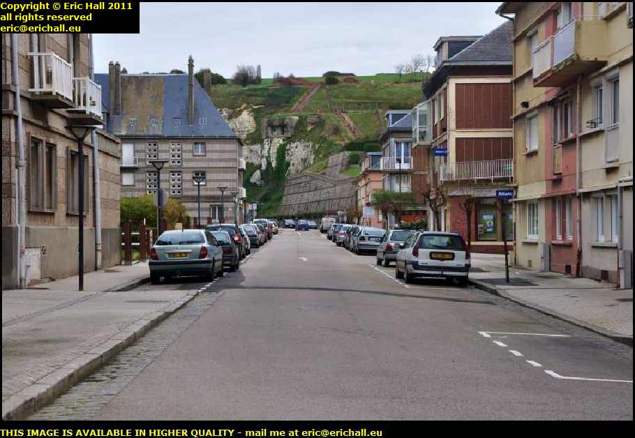
memorial 51st highland division st valery en caux franceIn 1950 a memorial stone to the 51st Highland Division was erected on the cliffs on an eminence that dominated the town.

That’s it up there on the skyline in the centre of the photograph.

The erection was, apparently, something of a ceremony, with the pipers of the Black Watch playing “The Last Post”.

st valery en caux franceI actually saw a photograph of the town on that occasion, and it didn’t half look a mess – even 5 years after the end of the War.

The town was fortified quite heavily by the Germans as part of “The Atlantic Wall” so it’s no surprise that heavy fighting took place around here later in the War.

The amount of destruction in the town, and the fact that the fortifications escaped so lightly, is some kind of testament to German thoroughness.

st valery en caux franceThat is of course one reason for visiting the town. There are plenty of others too.

It’s quite a historic place, being first mentioned in a Charter of 990, although legend has it that the town actually dates from the 7th Century when a religious institution was founded here as part of the plans to evangelise the coast.

Nothing has been seen to confirm this, and no trace of a likely building has ever been discovered.

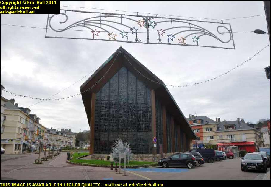
Chapelle Notre Dame du Bon Port st valery en caux franceFirst port … if you pardon the expression … of call in St Valery-en-Caux has to be the Chapelle Notre Dame du Bon Port – the Chapel of Our Lady of Bon Port – the “Good Port”.

This magnificent wooden structure, designed by Raymond Jules Lopez, and situated in the … errr … Place de la Chapelle.

It dates from 1963 and replaces a much older chapel that was destroyed during the war.

Chapelle Notre Dame du Bon Port st valery en caux franceAnd in an irony that seems to have gone right over everyone’s head, the stones from the original chapel – about which nothing much seems to be said – were used for a very secular purpose – to build the casino in Veulettes sur Mer.

Its stained-glass windows, designed by André-Louis Pierre, are said to be magnificent and are best viewed from inside, something which I was very keen to do.

And so in a situation that somehow only I seem to be able to manage to conjure up, the church is closed today and the doors are locked.

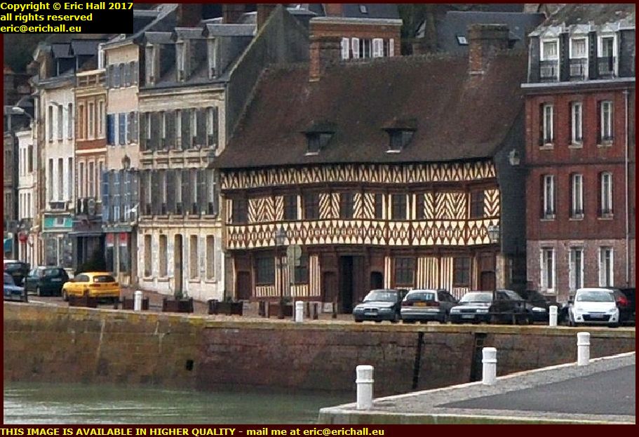
Maison Henri IV st valery en caux franceThe most magnificent building in the town is what it known as the “Maison Henri IV”.

Built in 1540 by the wealthy Guillaume Ladiré, it earns its name from a story that suggests that the French King Henri IV spent a night here in 1593.

It’s said by many to be the finest “Normandy-style” half-timbered house in the region and who am I to disagree?

Yet another claim to fame possessed by the town, and about which people are quite reticent, is the fact that a major rail crash took place here on 17th January 1945.

The fact that it happened in wartime and involved armed forces means that it never received the publicity that it might otherwise have done had a news blackout not been in force.

A train loaded with American soldiers was coming into town when a brake failure cause it to overrun the buffers at the station. 89 American soldiers were killed and 152 injured.

Finally, and most importantly, there’s a transatlantic telephone cable – the TAT 14 – between North America and Europe that runs out to sea here. According to the American Secret Service, this is a vital communications link and so the area is considered by the US military to be a “strategic point”.

We all know what that means. Iraq and Afghanistan were considered by the US military to be “strategic points” too.

Blimey! Is that the time?

My ferry leaves in 90 minutes and I have about 50 kms to travel. And to check in, and to board. And I’ve never been to le Havre so I don’t know where the port is!

I shall have to put my skates on!

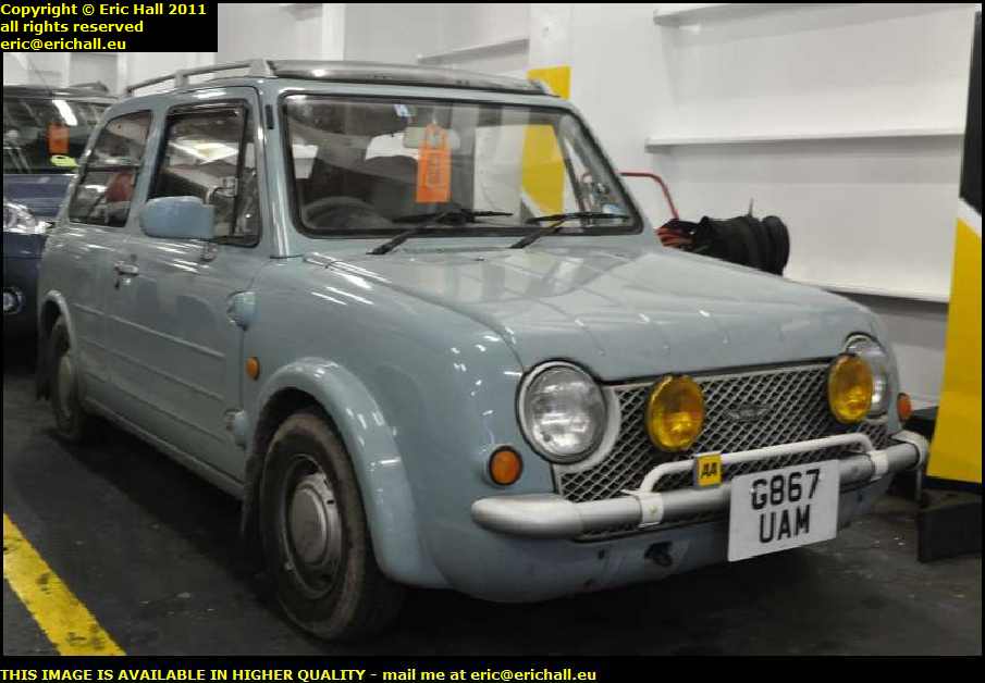
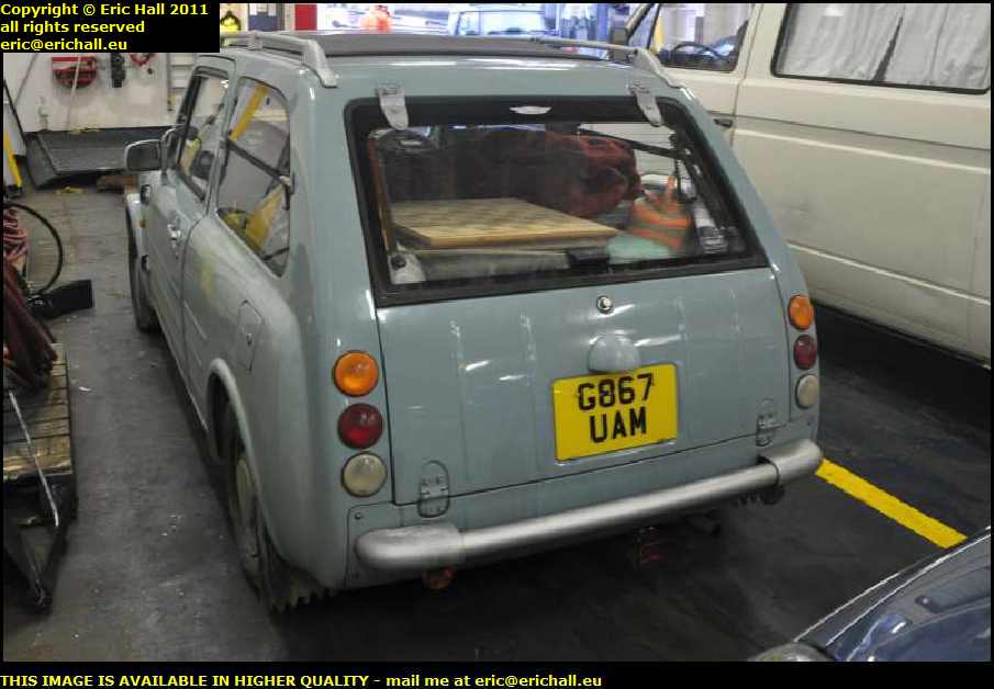
nissan pao grey import le havre franceMade it to the port and on the ship with half an hour to spare (good old Caliburn) and I’m glad that I did because just look at my travelling companion!

It’s one of these Nissan Pike-style retro cars made in Japan in the late 80s and early 90s. This one is the Pao – the estate-car version.

Rare as they come, I’ve never seen one before and I probably won’t ever see one again because these had a very limited production run – and that was for Asia only.

nissan pao grey import le havre franceThey don’t have a class type approval and so were never officially imported into the UK.

Only individual cars can be brought in – the so-called “grey imports” – and they need modifications before they can be used on British roads.

You’ll notice the add-on rear foglights underneath the rear bumper, for example. That’s a real give-away if you want to see if a car is an official mainstream import or a grey import like this.

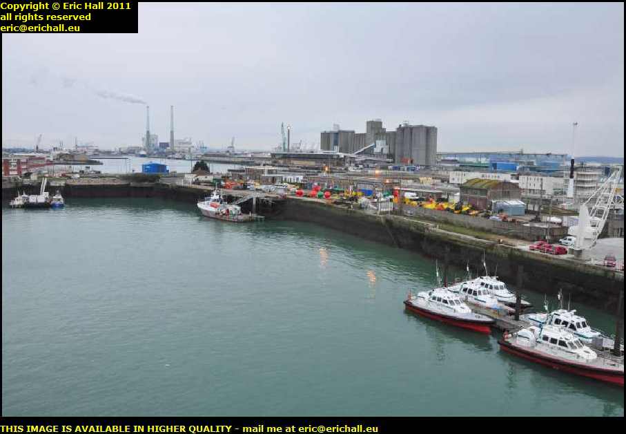
le havre franceAs for me, having parked up Caliburn and photographed the Pao I went hot-foot, or chaud pied as they say around here, up to the deck to see what I could see.

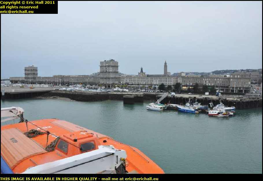
Having spent my early afternoon in St Valery-en-Caux rather than Le Havre, I hadn’t seen too much of the city, so I needed to see what I could see from on top.

First thing to see of course is the River Seine – the town is situated right at the mouth of the river.

le havre franceIt’s not really a historic place as such, like many French towns and cities. It’s effectively a “planned town” built on the orders of King Francois 1st in 1517.

With the expansion of France’s maritime power in the 15th and 17th Century, the town was intended to take advantage of its ideal situation here.

As more and more ships were sailing, and the ships themselves grew in size, the port of Rouen was overwhelmed. Goods could be unloaded here and trans-shipped by barge up the Seine to Paris

le havre franceMind you, that’s not to say that there was never a setttlement here. Evidence has been uncovered suggesting settlement from the dawn of European humanity.

More-or-less continual occupation from Neolithic times is suggested.

There was an Abbey here in the immediate vicinity at the time of WIlliam the Conqueror and there were certainly a couple of small fishing villages here when Francois I became interested in the site.

le havre franceBut like most things, it was the era of the Industrial Revolution that saw the spectacular growth of the port.

Continual development has been taking place over the last 180 years, and it’s now one of the major ports of the country.

There’s a considerable amount of heavy industry as you might expect. Oil refineries, cement works and all of that, all based on the raw materials that are brought in.

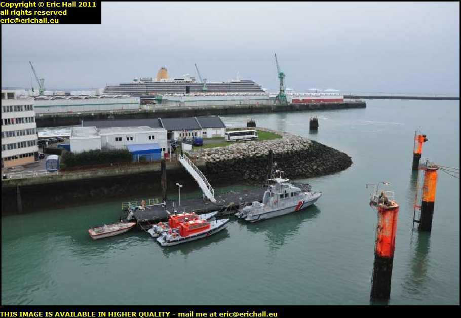
le havre franceMammoth cruise ships call here today as you can see.

But that’s just a sad reminder of the days when the great French transatlantic liners of the Compagnie Générale Transatlantique sailed from here.

And the huge ship-building works – the Ateliers et Chantiers du Havre – closed down in 1999. That was a major blow for the town.

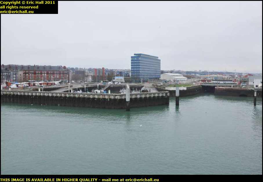
le havre franceThe city was totally destroyed by the Allied air forces during the war – and the rebuilding has not been kind, as you can see.

The worst of the air raids took place on 5 an 6 September 1944 by the RAF Bomber Command.

They dropped a total of 10,000 tonnes of bombs on the city, destroyed 12,500 buildings and killed over 3,000 civilians. 350 boats and ships were sunk.

And all to no purpose either because the port had already been badly damaged and the German defenders were camped well outside the town.

The reason of this destruction has always for the French been a total mystery. Many conspiracy theories, such as the wish to damage French post-war maritime commerce, have abounded ever since.

In the lounge of the ship for five and a half hours of one of the most comfortable crossings of the English Channel, I was in Pompey – or Portsmouth to the uninitiated.

Out of the docks and round the back streets is one of the best chippies in the whole of the UK and I felt so much better once I’d wolfed down a helping of beans and chips liberally doused in malt vinegar.

The M27 and the M3 to Winchester took me to the A34 to Oxford, and then the A43 as far as the edge of Towcester where there’s a quiet lay-by for the night.

And guess who forgot to plug his heated seat in so that he could warm up his bed?